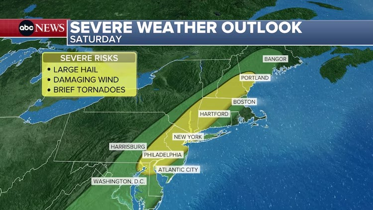
(NEW YORK) — The threat for severe weather on Saturday is shifting east, putting more than 25 million people on alert from eastern Pennsylvania up into southern Maine.
This includes those in Philadelphia, New York City; Allentown, Pennsylvania; Poughkeepsie, New York; Hartford, Connecticut; Manchester, New Hampshire; and Portland, Maine.
Damaging winds, large hail, and lightning will be possible early Saturday evening into the overnight across this area, with a slim risk of a few brief tornadoes.
Flash flooding will also be a concern for some of these areas, with the highest risk (Level 2 of 4) stretching from Philadelphia to Bridgeport, Connecticut.
Multiple rounds of heavy rain from overlapping and training storms will be capable of producing localized to scattered areas of flash flooding, especially with the heaviest downpours or in areas known to flood.
These storms will begin firing off after noon on Saturday and continue into the overnight hours.
The inclement weather is expected to hit Philadelphia to New York City from 2 to 8 p.m., with some lingering rain into the overnight; Poughkeepsie and Hartford up into Springfield, Massachusetts, as early as 2 p.m., continuing to about 6 to 8 p.m.; and Portland down to Boston from 4 to 10 p.m., with heavy rain continuing overnight.
Boston is not facing the highest threat for flash flooding or severe weather, but strong storms are expected to roll through the area.
Rain showers will continue to linger into the first half of Sunday as this cold front continues to move through the region, with the region drying out Sunday afternoon into the early evening.
Behind the cold front that is triggering these storms will be noticeably cooler air for Sunday.
Copyright © 2025, ABC Audio. All rights reserved.
- Luigi Mangione asks to delay federal trial - March 18, 2026
- Moderate geomagnetic storm forecast for tonight: What to expect - March 18, 2026
- ‘Family torn apart’: Kouri Richins juror describes emotional murder deliberations ahead of guilty verdict - March 18, 2026