
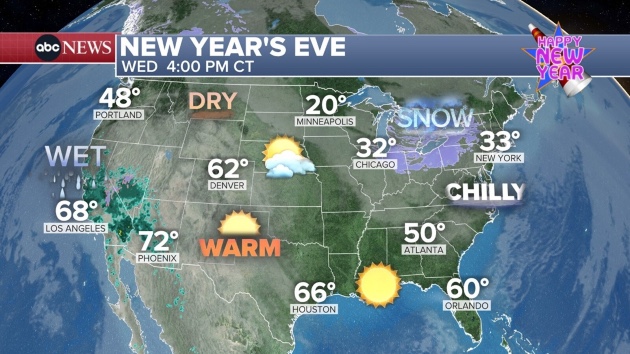
(NEW YORK) — More rough weather is forecast on both coasts when the ball drops on Wednesday night, ringing in 2026.
On the West Coast, more rain is expected across a drenched Southern California, where residents are still recovering from last week’s flooding.
The new storm will bring widespread rain and mountain snow starting New Year’s Eve and continuing through the end of the week.
An excessive rainfall risk level of 2 out of 4 is in place in the Los Angeles and Santa Barbara areas on Wednesday and Thursday.
Through Friday, 2 to 4 inches of rain is possible at higher elevations, and 1 to 2 inches at lower elevations like downtown Los Angeles.
In the Northeast, another cold front is moving through on Wednesday and Thursday, which brings the slight chance for a few snow flurries to mix in with confetti as the ball drops in Times Square. But no measurable snow accumulation is expected and the flurries will be gone by sunrise on Thursday.
The only part of the Northeast to get intense snow is the Great Lakes, where lake effect snow will continue through the week. A winter storm warning is in place in Orchard Park, New York, home of the Buffalo Bills, where residents could see up to 3 feet of snow by the end of New Year’s Day.
The rest of the country will be dry, with above average temperatures through the Plains and much of the South on New Year’s Day.
Copyright © 2025, ABC Audio. All rights reserved.

- Holdout juror in Lindsay Clancy trial says he ‘didn’t have any doubts’ during deliberations - September 18, 2026
- Bryan Kohberger’s family says they support his attempt to challenge conviction - September 17, 2026
- Popular frozen dessert voluntarily recalled due to potential presence of stones - September 17, 2026